Images from Orbit
Astronauts aboard the International Space Station have taken nearly half a million photographs. You'll see some of them in this collection. 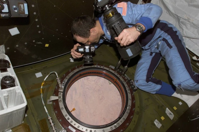

Astronauts aboard the International Space Station use a portable camera, which has taken more than 450,000 photographs of Earth from a distance of approximately 354 km since November 2009. As Cindy Evans of NASA's Johnson Space Center in Houston notes, camera flexibility and the ability to change lenses and create interesting angles are just a few of the advantages of a portable camera over a stationary one. In this photo, Donald Petty photographs Earth from the Destiny laboratory on the International Space Station. (NASA) 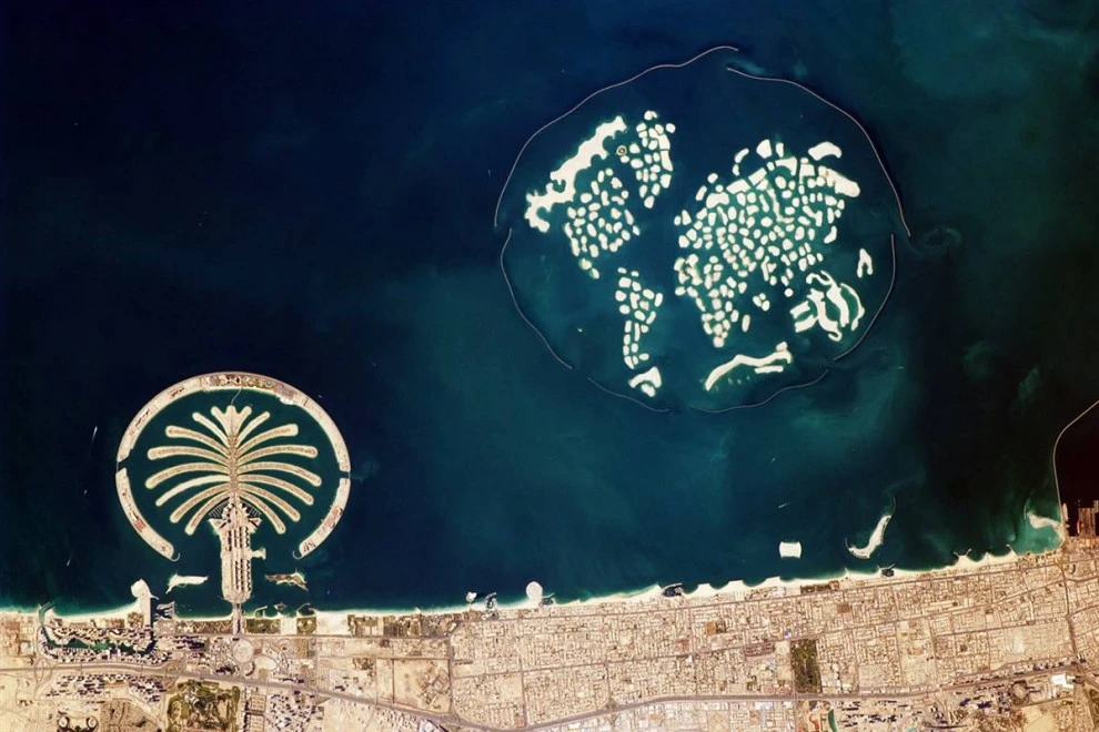

Как садят рис
Смотреть видеоAmong the best uses of the space station, according to Evans, is the perspective it offers for human development. For example, this January 13, 2010, image of Dubai in the UAE shows the city from the air. Pictured on the left is Jumeirah, a palm-shaped island created using more than 1.7 billion cubic feet of sand. On the right is the World Islands, completed in 2008, which required 11.3 billion cubic feet of sand. The Burj Khalifa, the world's tallest skyscraper, opened on January 4th, can be seen at the bottom right. (Image Science & Analysis Laboratory, NASA Johnson Space Center)
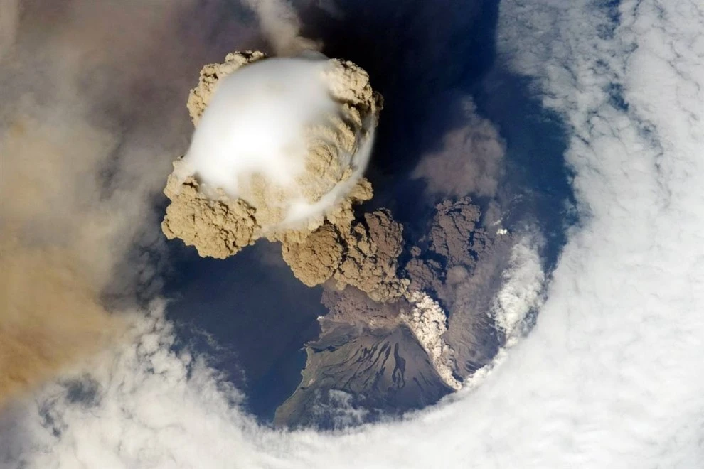
On June 12, 2009, the spacecraft successfully passed over Sarychev Volcano in the Kuril Islands, northeast of Japan, during the early stages of its eruption. Scientists are particularly interested in how clouds form above and around the ash plume. "Being able to understand how a volcanic eruption begins is one of the benefits of science," says Evans. (Image Science & Analysis Laboratory, NASA Johnson Space Center)
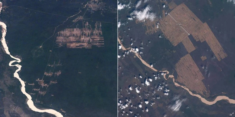
Astronauts have been using portable cameras for 45 years, creating a complete archive of the gradual changes in the earth's landscapes in various areas. These images show the progression of tropical forest clearing in eastern Bolivia for agricultural land. The photo on the left was taken from the space shuttle in November 1995. The photo on the right is a more detailed view of the same region in November 2008. (Image Science & Analysis Laboratory, NASA Johnson Space Center)
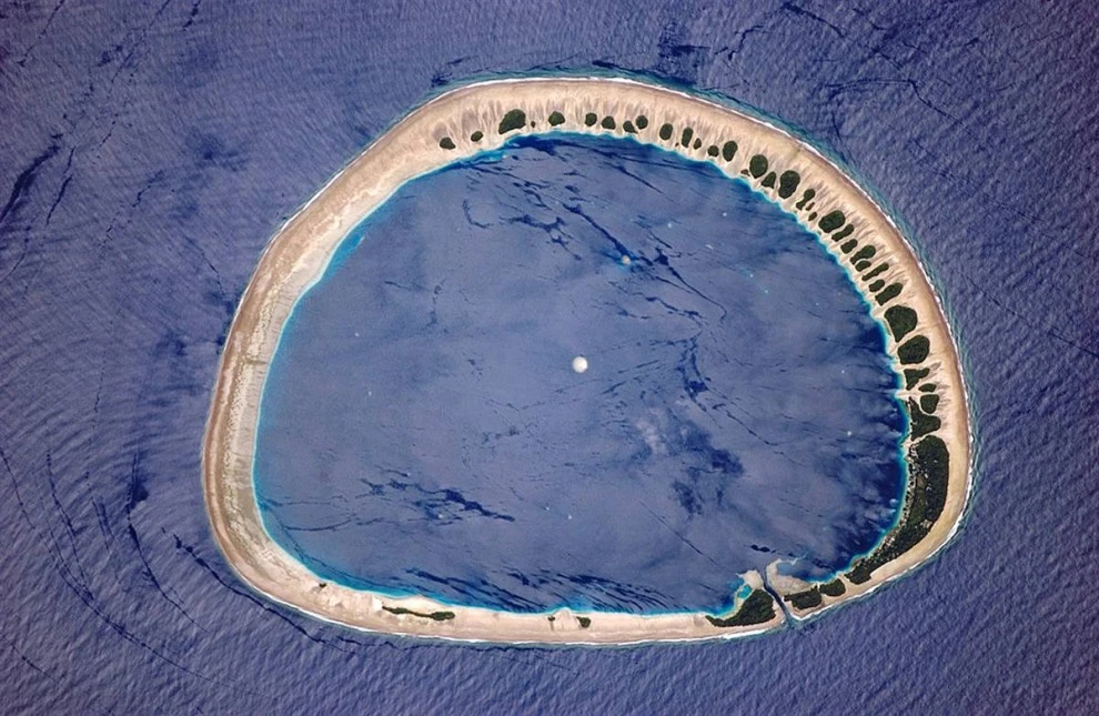
Astronauts orbit the western Pacific Ocean, they don't see land for a long time. Then come the atolls and coral reefs, and that's when astronauts reach for their cameras. "They see these pearls in the ocean and want to capture them in detail," says Evans. Nukuoro Atoll in the Caroline Islands of northeastern Papua New Guinea was captured on May 31, 2006. The island's 42 patches of green are swept by easterly winds. About 900 people live on the island in small settlements. Images taken from the International Space Station are used by conservationists to monitor the health of such places. (Image Science & Analysis Laboratory, NASA Johnson Space Center)
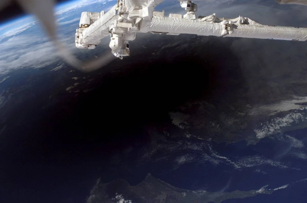
Solar eclipse enthusiasts were willing to travel to the ends of the Earth just to see the moon block the sun. Space station astronauts captured this image of the lunar shadow cast over Turkey, northern Cyprus (by the way, tours to Cyprus are enjoying growing demand), and the Mediterranean Sea during the total solar eclipse of March 29, 2006. (Image Science & Analysis Laboratory, NASA Johnson Space Center)
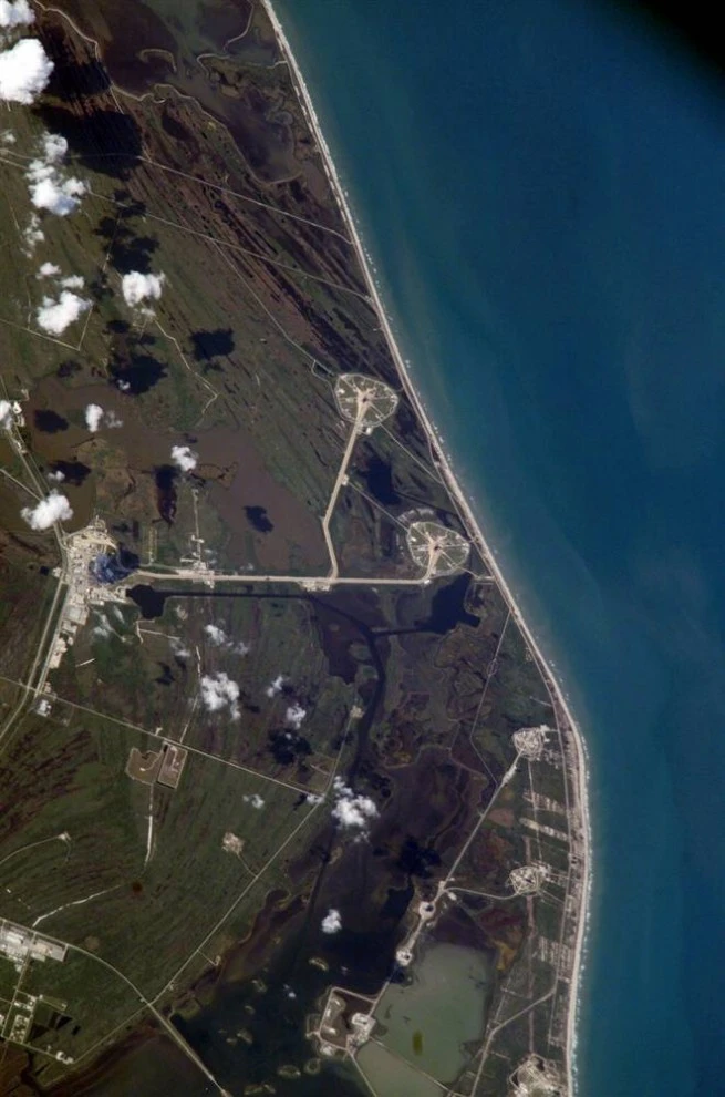
This image was taken on April 6, 2005, as the station passed over the Kennedy Space Center in Florida, while the shuttle Discovery was being prepared for launch on Launch Pad 39-B. The shuttle reunited with its solid rocket booster approximately halfway through its 13-hour journey from the Launch Assembly Building (left in the photo) to the launch pad (top center). The shuttle successfully launched on July 26, 2005, delivering all necessary supplies to the station. (Image Science & Analysis Laboratory, NASA Johnson Space Center)
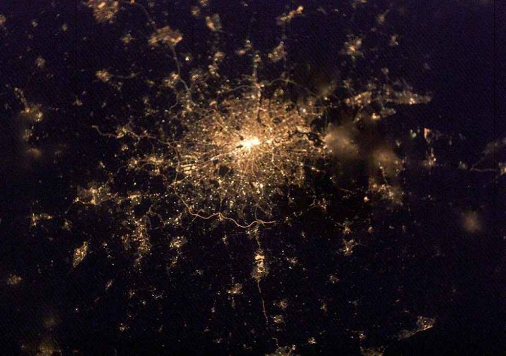
Cities are among the most beloved subjects for NASA astronauts. "People like to imagine that it's not just satellites looking down on them, but also people orbiting the Earth," says Evans. This image of London taken on February 4, 2003, clearly depicts the city's population density. The city center is the brightest point, with streaks of light extending from it. Blurred areas in the photo may be clouds or fog. (Image Science & Analysis Laboratory, NASA Johnson Space Center)
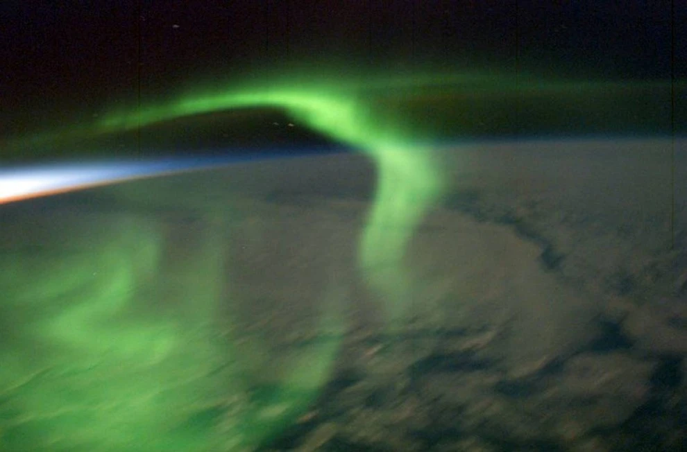
Some crew members marvel at the aurora borealis—lights in the night sky that appear when oxygen and nitrogen atoms are bombarded by solar particles. Astronauts are learning to take meaningful photographs of the aurora borealis. Expedition 22 crew member Donald Petit captured several images of the aurora borealis in January and February 2003, including this one just after sunset. (Image Science & Analysis Laboratory, NASA Johnson Space Center)
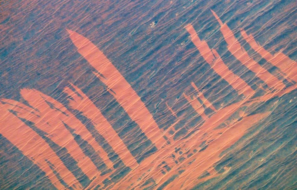
A fire raging in Australia's Simpson Desert left red scars. The orange streaks in this November 23, 2002, image appeared as the fire swept across the desert scrub, revealing the sand dunes beneath. The pattern suggests the fire moved from the lower left along the undulating dunes, downwind. The wind then shifted direction by about 90 degrees, causing the fire to burn across the existing streak. These scars will disappear as new vegetation grows. (Image Science & Analysis Laboratory, NASA Johnson Space Center)
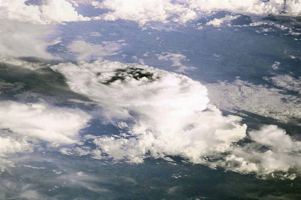
From the very beginning, astronauts on the space station have been fascinated by the process of storm formation. This photo is the first image from the space station—storm clouds over Earth. The photo was taken with an electric camera. Today, the space station is equipped with high-quality Nikon digital cameras. (Image Science & Analysis Laboratory, NASA Johnson Space Center)

Download
Archive size 1.52 Mb, downloaded 23 times