Carlo Bossoli (1815 – 1884). Crimea (55 works)
Разрешение картинок от 981x640px до 1024x792px
The fascination with Crimea, especially in the 20-30s of the 19th century, is largely associated with romantic idealization and coincides with the era of retrospective moods in culture. The Romantic Age aroused interest in the distant past, in the harsh Middle Ages with its ideals of chivalry, in the mysterious East with its picturesque wild nature, unique way of life and life full of danger and courage. This spiritual atmosphere is manifested in the perception of Crimea: a fragment of Ancient Hellas, a corner of the exotic East, a pristine paradise, “terra incognita”...
A worthy place in the brilliant galaxy of illustrious names is occupied by the Italian Carlo Bossoli (1815-1884). His work, permeated with light and the festive atmosphere of the South, allows you to see Crimea through the eyes of the artist’s famous contemporaries, to feel like a pioneer of the legendary land of Taurida.
A talented draftsman, tireless traveler, author of amazing travel sketches, one of the founders of the tradition of “fine journalism,” Carlo Bossoli will experience great fame during his lifetime. His human and creative destiny was largely determined thanks to the active participation of M.S. Vorontsov, as well as the artist’s life in Odessa and Crimea.
Mikhail Semenovich Vorontsov is truly history in the memorial space. As contemporaries asserted, “that brilliant page of the South of Russia begins with him, of which our Fatherland can be proud.” The era of Prince Vorontsov, who in 1823 assumed the office of Governor-General of Novorossiya, plenipotentiary governor of the emperor in Bessarabia (and since 1844 in the Caucasus), marks the true economic and spiritual development of these lands. M.S. Vorontsov personally assisted the expeditions, sought funds, provided scientists with his libraries and even the family archive. As a result, valuable publications about the nature, history, economics, and geography of the region appeared. At different times, with the “unfailing assistance of an enlightened ruler,” academicians P. Keppen, C. Montandon, T. Vanzetti, archaeologist N. Murzakevich, historian and linguist A. Firkovich, artists G. Chernetsov, C. Bossoli traveled through the Crimea and the Caucasus. .
Carlo Bossoli was born in the Swiss city of Lugano. Five years later, the family moved to Odessa. This choice is not accidental. By that time, Odessa was the most important Russian trading port on the Black Sea, the construction of which was led by de Ribas, a native of Italy. By the beginning of the century, Italians made up 10% of the city’s population.” Attracting foreigners to the southern borders of Russia, giving them numerous benefits was part of the policy in the development of trade, foreign relations, and culture; politics, brilliantly continued by M.S. Vorontsov. This is how a colony of “Russian Italians” was formed in Odessa. At first, it was naturally dominated by merchants and sailors. Craftsmen, pharmacists, school teachers, and people of art followed them. Famous architects, sculptors, artists settled in Odessa: Torricelli, Nannini, Fazardi, Bigatti...
Having found himself in an artistic environment, K. Bossoli early discovered his extraordinary artistic talent, which was greatly facilitated by his work in an antique shop selling prints, where in his free time he painted and copied a lot. The first teachers were probably the Odessa artists of his circle. It is known that since 1828 he has been working in the studio of Nannini, the artist of the Odessa Opera. Soon the successes of the talented illustrator and landscape painter were noticed by Count Vorontsov, who ordered him to work with views of Odessa.
Fortune clearly favored the young Italian. However, like E.K. Vorontsova, on whose advice and insistence C. Bossoli went to Italy. He spent a little more than a year there (spring 1839-summer 1840): he studied in depth the classical and modern schools of painting. Upon his return, the artist accepts the invitation of M.S. Vorontsov and goes to the Crimea, to Alupka. Was this the first visit? We have no such evidence. But the fact that C. Bossoli lived here in 1840-1842 is known for certain. Having traveled the entire peninsula as a traveler, explorer, and painter, he expressed his impressions in a series of beautiful watercolors and gouaches (some of them are kept in the Hermitage). The works of 1840-1842 convince us that it was in the Crimea that the artist’s creative style finally took shape: masterly mastery of drawing techniques, realism, a deep sense of nature and perspective.
In 1843, at the insistence of his mother, who dreamed of returning to her homeland, C. Bossoli left Russia, where he lived for 23 years. He will travel halfway around the world, gain fame as an iso-reporter (his travel notes were published in many prestigious publications, in particular in Time); for some time he would even be an English court painter. But the charm of blessed Taurida remained in his heart forever.
An album of color lithographs, “The Beautiful Scenery and Chief Places of Interest throughout the Crimea,” was published in 1856. As you know, at that time Europe was experiencing the Eastern (Crimean) military campaign. There is information that in 1855 C. Bossoli visited the Crimea and captured military events in several poignant,
dramatic work. They fundamentally opposed the false-heroic responses so common in the countries of the anti-Russian military coalition. In the same year, K. Bossoli received an order from the large London publishing house Day&Son for a large album with views of the Crimea. But, probably, the publishers did not dare to contradict the official course and preferred the drawings of the Crimean cycle of 1840-1842. The album was a kind of “guide de voyage” - a guide to Crimea for officers and soldiers of the allied armies. Considering the special feeling of reverence for the Crimean land, as well as the anti-militaristic sentiments of K. Bossoli, it can be assumed that the publication of the album was an attempt by the artist to convince how beautiful this land is, how unique its monuments are, which must be preserved even in fierce battles.
By now, the publication has become an extreme rarity. The technique of color lithography is labor-intensive; the number of prints from one matrix is limited. It is impossible to establish how many of C. Bossoli's 1856 albums have survived.
When preparing the publication, C. Bossoli selected subjects that most fully illustrate the diversity of the natural landscapes of the peninsula, and the richness of its history, where eras, peoples, cultures changed... The master tried not only to reliably record the monuments they left, but also to convey their authenticity Charm.
The album “Landscapes and Sights of Crimea” presents a detailed panorama of life in the midst of luxurious nature: magnificent views of the South Coast and sea vistas, landscapes of the Crimean mountains and the quiet beauty of cozy valleys, the romantic ruins of ancient Chersonesus and the harsh walls of Genoese fortresses, mysterious “cave cities”, abandoned old cemeteries and the exoticism of the Muslim East... Traces of bygone civilizations - from antiquity to modern times.
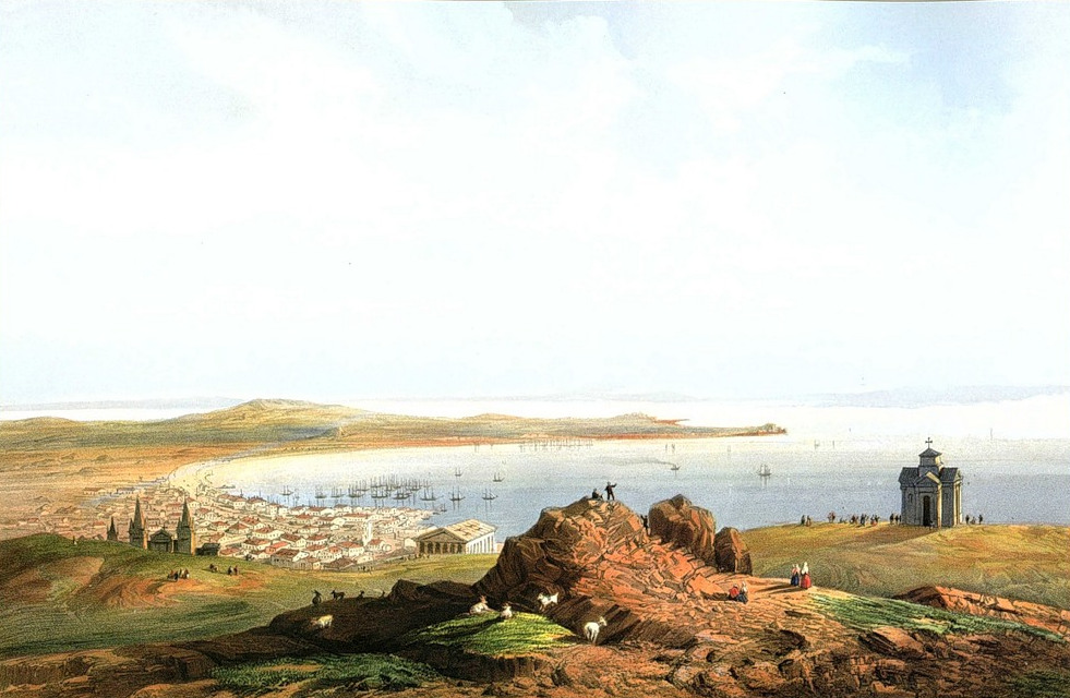
1.Evpatoria
“This is the view from the sea coast. On the left is the customs building; in the center there is a caravanserai and a large mosque; in the distance there is a new Russian church.
In this, one of the most densely populated cities in Crimea, about 15 thousand people lived before the war.”
The history of the city goes back thousands of years, to the settlements of the Copper and Bronze Ages, to the dominance of the Taurians and early Scythians. At the turn of the VI-V centuries. BC e. The Greek city of Kerkinitida appeared here, as many ancient authors tell about it (Hecataeus of Miletus, Herodotus, etc.). Kerkinitida was a significant center of agriculture, crafts and trade. Destroyed by the invasion of barbarians (Huns) in the 4th century. n. e. During the time of Turkish rule (from 1475), the city was called Gezlev (in Russian documents - Kozlov). It was a recognized international center, the notorious slave market of Europe, and also the largest city of the Crimean Khanate, after Bakhchisarai. After Crimea came “under the Russian State” (1783), the city was renamed Yevpatoria (1784).
2. Entrance to Sevastopol from the sea
“On the left is Fort Constantine; on the right you can see Fort Alexandra and Fort St. Nicholas; in the center, in the background, are the Inkerman lighthouses.”
Stone two- and three-tier battery forts to protect Sevastopol from the enemy fleet were erected in 1846-1847. under Admiral M.P. Lazarev. Of the forts mentioned by the artist, only Konstantinovsky and Mikhailovsky have survived.
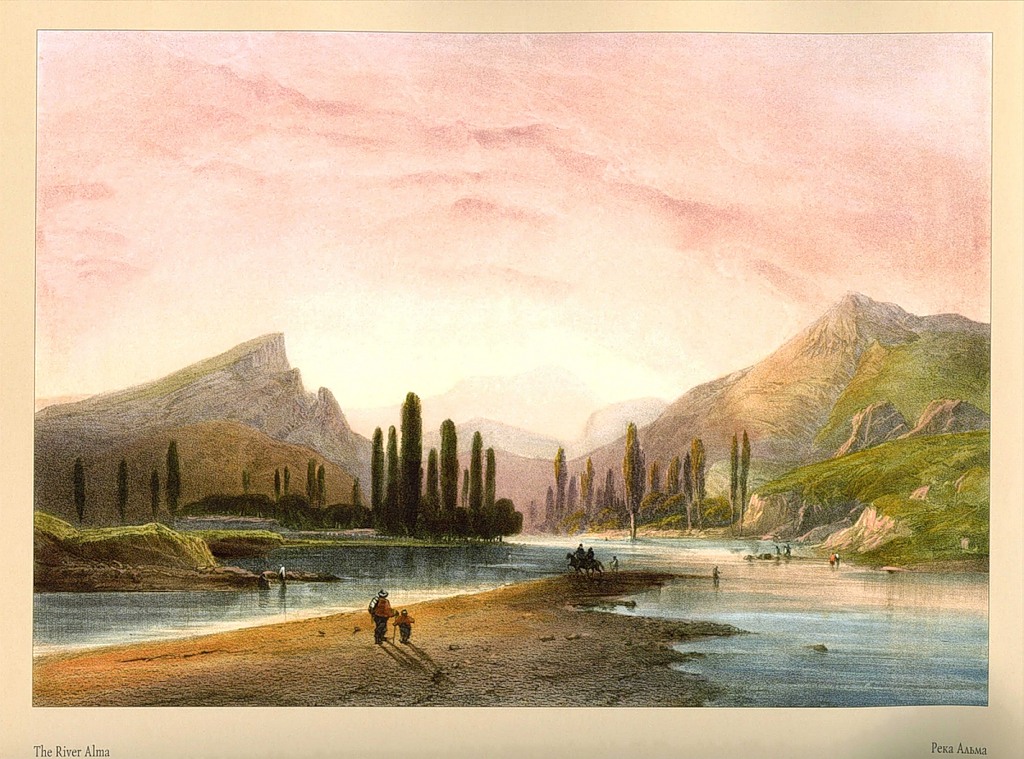
3. Alma River
“View from the road from Simferopol to Bakhchisarai. Chatyr-Dag, the highest mountain of the peninsula, rises in the background.”
The highest mountain on the peninsula is not Chatyr-Dag, as C. Bossoli believed, but Roman-Kosh - 1545 m.
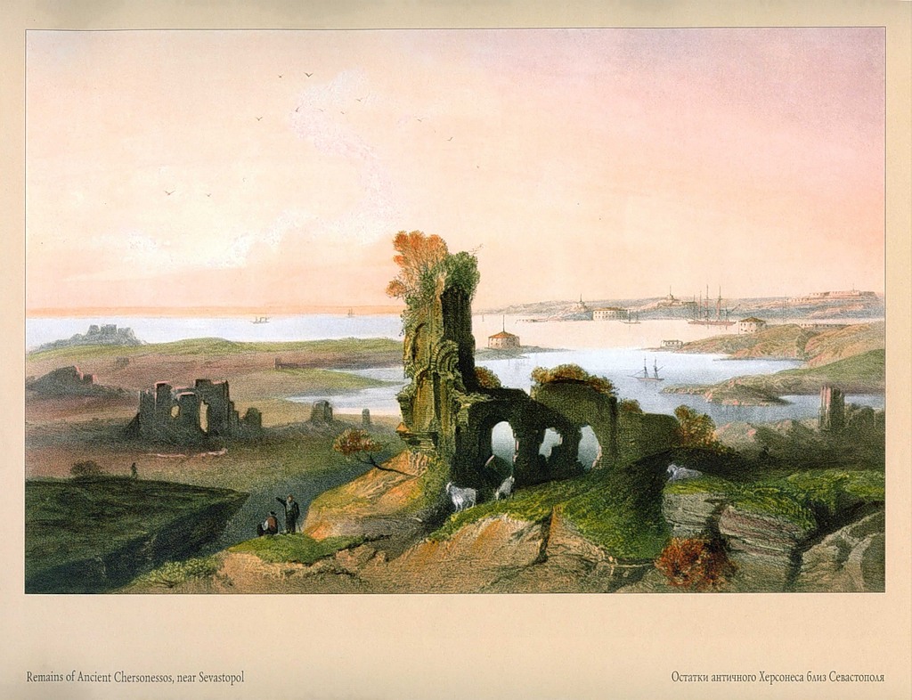
4. Ruins of ancient Chersonesus near Sevastopol
“In the foreground are the ruins and the Chersonesos Bay; in the background are the Fort of Constantine and the entrance to the Sevastopol harbor.”
Chersonesos is an ancient Greek polis founded at the end of the 5th century. BC e. colonists from Heraclea Pontica. A major economic, political and cultural center of the ancient world. In the V-VI centuries. n. e. was a stronghold of the Byzantine Empire on the northern coast of the Black Sea. A significant event in Russian history is associated with Chersonesus: the Grand Duke of Kiev Vladimir received holy baptism here. In the XIII-XIV centuries. the city was repeatedly subjected to devastating invasions of the Mongol-Tatars. Having existed for almost two thousand years, by the end of the 15th century. it is in complete decline. By the time of C. Bossoli's travels, Chersonesus was a romantic ruin with the remains of fortress walls, towers, and city gates.
5.Kacha River
“View from near the village of Biya Sala.”
The village of Biya-Sala is a modern village. Verkhorecheye, Bakhchisarai district.
6.View of Fort St. Nicholas
“One of the largest forts, where about 300 guns are assembled, protecting both the entrance to the large Sevastopol Bay and the military harbor.”
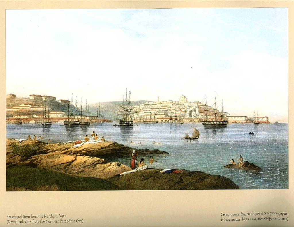
7. Sevastopol, visible from the Northern Forts
“In the foreground is the entire city and the military port; on the right are Fort St. Nicholas and Fort Alexander; on the left is the large harbor of Inkerman Bay.”
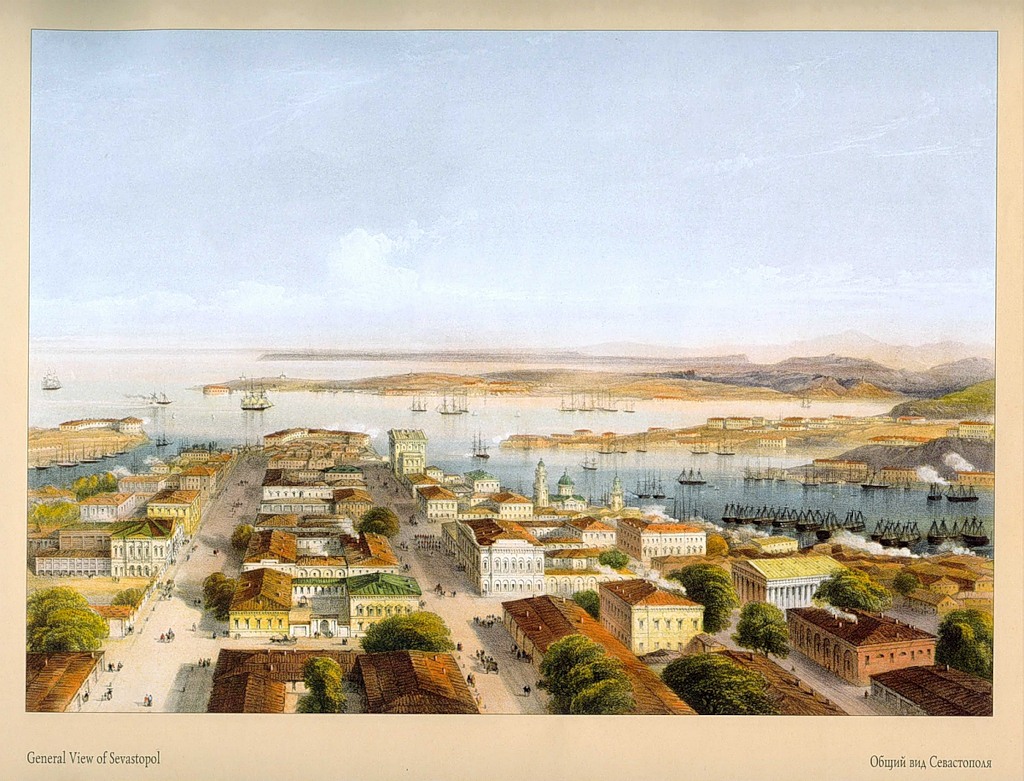
8. General view of Sevastopol from the observation tower in the city center
“The tallest building in front is the library; on the right - the Cathedral and the Admiralty Tower, a military port, Fort St. Paul, docks and part of Matrosskaya Sloboda; on the left is Artillery Bay; across the bay, in the background, is Fort Constanti
on, Northern fortification and Inkerman lighthouses.”
The city was founded in 1783. At first it was called Akhtiar, after the name of a small settlement and a bay, later renamed Severnaya. It was in the Akhtiar harbor that the first Russian ships came to winter for the winter; A barracks for the crew was also built there - the first building of the future city. The official name Sevastopol (translated from Greek - a majestic, worthy city) is first found in the written order of Catherine II to Prince G. A. Potemkin dated February 1, 1784. In 1804, the Russian government officially declared Sevastopol the main military port of the Black Sea
fleet (instead of Kherson).
9.Arsenal Harbor, or Military Port, Sevastopol
“In the foreground are old battleships, now used as a prison; on the right are sailor barracks; on the left is part of the city.”
Barracks for sailors (for 6 thousand people) were built under Admiral M.P. Lazarev. The buildings have been preserved.
10.Interior of an early Christian church
“Hollowed out in the Inkerman rocks.”
C. Bossoli means the Church of St. Clement. It is known that the Roman Bishop Clement for preaching the teachings of Christ in 96 was exiled by the Roman Emperor Trajan to hard labor in a quarry near Chersonese. Here he continued to preach Christian teachings and, converting the local population to Christianity, contributed to the emergence of numerous temples. An angry Trajan sent a punitive detachment that destroyed many of Clement’s followers; the preacher himself was executed in 101. According to legend, the temple, known as the Church of St. Clement, he carved with his own hand. This is not true, since the emergence of the temple dates back to the 8th - beginning of the century. IX century; it was probably created by monks - refugees from Byzantium.
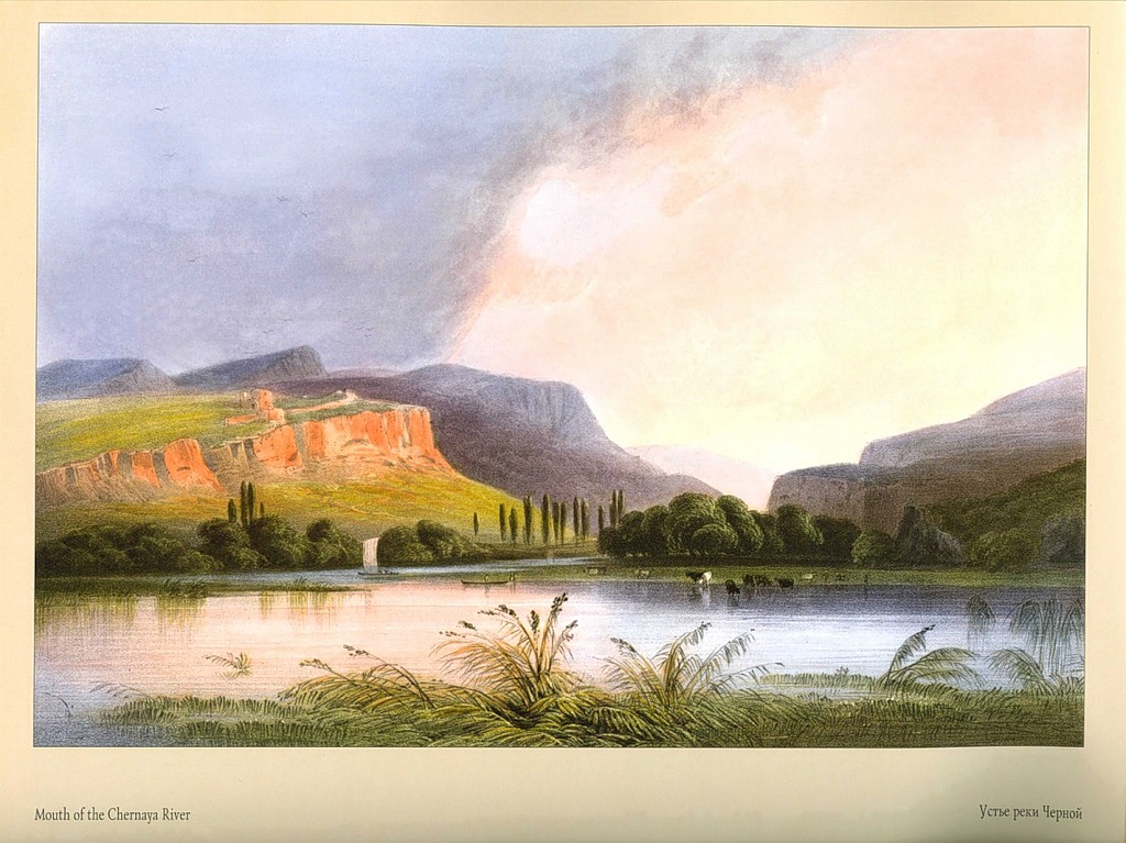
11. The mouth of the Chernaya River at its confluence with Inkerman Bay and Sevastopol Harbor
“On the left you can see the Inkerman rocks; behind are the mountains at the entrance to the Baydar Valley.”
12. Remains of Genoese fortifications in Inkerman
“The Sevastopol harbor is visible in the background.”
The fortifications depicted in the picture did not belong to the Genoese, as the artist mistakenly believed, but to the Theodorites. The large medieval principality of Theodoro (Mangup Principality) was located not far from Bakhchisarai, on the vast fortified mountain plateau of Mangup. It existed from the 13th century until the conquest of the entire peninsula by the Turks (1475). For centuries, the powerful state maintained economic and political independence and competed with the Crimean Khanate and Genoese cities. The picture shows the ruins of the Kalamita fortress, which was an outpost of the Principality of Theodoro and protected its commercial port.
13.View of the Inkerman Valley
“In the background you can see the Sevastopol Bay; in the lower reaches of the valley is the Chernaya River; on the right is the Inkerman rock, where a large number of caves have been found, which are said to have been carved out by Christians of early times to provide themselves with refuge from persecution.”
14. Monastery of St. George
“Located between Kamyshovaya Bay and Balaklava. Founded around the 10th century. The monks serve as chaplains in the Russian fleet in Sevastopol.”
There is a legend in Christianity that the monastery was created in 891 by the Greeks, saved by St. George during a storm near Cape Fiolent. An icon of St. George appeared to them on a rock in the bay, which was subsequently transferred to the monastery. C. Bossoli knew this legend, as evidenced by the plot of the drawing. However, the exact time of the founding of the monastery is unknown. An excellent expert on the history of Taurida, A. L. Berthier-Delagarde, believed that the monastery arose no earlier than the 15th century. His opinion is shared by many researchers. The artist captured the building of the new temple, erected in 1810-1816. on the site of a former dilapidated building. C. Bossoli's information about the service of monks on ships is reliable. However, in the Orthodox tradition they were called not chaplains, but hieromonks. During the Crimean War, the St. George Monastery was almost not damaged. The French commander-in-chief, Marshal Saint-Arnaud, gave orders for his protection. And, probably, not only because the Allied telegraph station was located here; They often attended daily services themselves. An infirmary for the wounded and sick was also set up here.
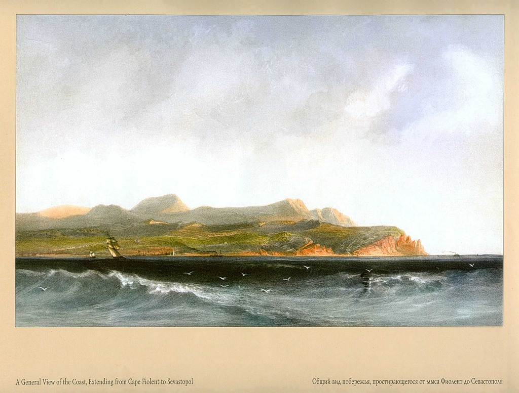
15. General view of the coast stretching from Cape Fiolent to Sevastopol
“Cape Chersonesos and Kamyshovaya Bay are visible in the center.”
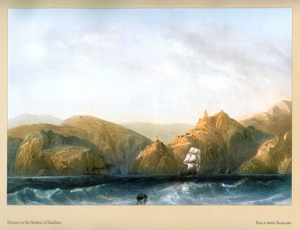
16. Entrance to Balaklava harbor
“On the hill are the remains of Genoese fortifications.”
Balaklava is located 12 km from Sevastopol, in a small picturesque bay. The ancient Greeks called it Sumbolon (Harbor of Symbols). It is believed that this particular place is described in Homer's Odyssey as the port of the Listrygonians of Aamos - the mythical giants whom the brave navigator and his companions encountered.
17. General view of Balaklava from the side of the Genoese fortifications
“On the left is the entrance to the harbor; on the right is the city.”
In the middle of the 14th century. Sumbolon was conquered by the Genoese and named Chembalo. In 1475, the city was captured by the Turks, who gave it the name Balyk Yuve - Fish's Nest, transformed into Balaklava.
18. Balaclava, view from the shore
In the 40s XIX century Balaklava is a tiny town whose population (about
mainly Greeks) were engaged in fishing. During the Crimean War, the English fleet was based in Balaklava Bay.
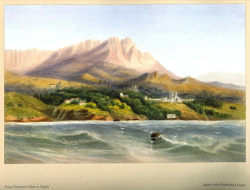
19. Palace of Prince Vorontsov in Alupka
“A magnificent structure made of green granite; costs about 20 million rubles; Almost 30 years were spent on its construction. Behind rises Mount St. Peter, one of the highest in Crimea.”
M. S. Vorontsov first visited Crimea in 1822. Deciding to settle on the coast, he acquired land in Alupka, Ai-Danil, Massandra, Gurzuf, etc. According to the prince’s plan, an estate was to be built in Alupka, which would become not only a summer residence, but also the main primary possession of the family name. The palace project was commissioned from the talented English architect E. Blore. He became famous by fulfilling orders from the English Royal Court, restored palaces in Oxford and Cambridge, and participated in the construction of Buckingham Palace in London. Vorontsov Palace is a masterpiece of E. Blore’s creative imagination. The architectural appearance harmoniously combines the architectural traditions of different eras and cultures. The northern façade of the palace recreates an English feudal castle in the Tudor style. The southern one, facing the sea, resembles the Alhambra - the palace of the Arab caliphs. The first work on the estate began in 1824 with the construction of a country house. The palace itself was built from 1830 to 1851, when the upper terrace and fountains were finally landscaped. The work was supervised by architect V. Gunt. While staying in the hospitable house of the Vorontsovs, C. Bossoli painted a series of beautiful watercolors (kept in the Hermitage). The drawings convince us that the main construction was almost completely completed by 1841.
The palace fits perfectly into the magnificent park ensemble - a monument of landscape architecture created by gardener K. Kebakh.
20.Tatar house in the village of Alupka
“Such houses are usually built adjacent to a large rock, the side of which serves as a wall. On a flat roof, when the weather is good, the inhabitants usually gather, working or enjoying each other’s company.”
21.Interior of a Tatar house
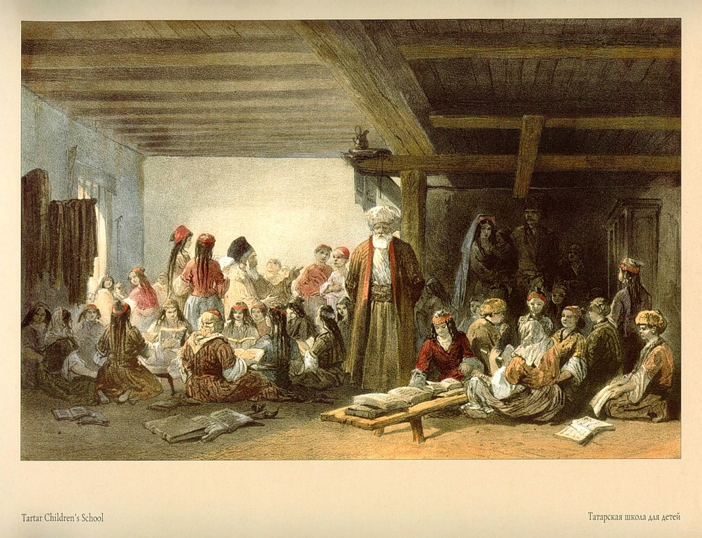
22.Tatar school for children
23. Peaks of Mount St. Peter
K. Bossoli uses the Latin version of the name. In Crimean toponymy there are many names that go back to Greek, or more precisely, to the Crimean version of the Modern Greek (so-called Rumean) language. The word Ay (Anya) means Holy (Holy). Hence the name Ai-Petri, which is still used today.
24.Cape and lighthouse of St. Theodore
“Between Alupka and Yalta.”
This is Cape Ai-Todor. In the early Middle Ages, the monastery of St. Theodore Tyrone stood here. The lighthouse appeared in 1835 for the needs of the hydrographic service of the Black Sea Fleet; subsequently reconstructed. Exists to this day. In the picture, Yalta is visible in perspective of the coast.
25.View of Yalta
“This city, located in the most beautiful part of the southern coast of Crimea, has especially grown in recent years and owes its prosperity to the patronage of Prince Vorontsov.”
Yalta is located in the central part of a natural amphitheater, bounded on the north by the Crimean Mountains, on the east by Cape Martyan, and on the west by Cape Ai-Todor. According to legend, the name goes back to the ancient Greek Gialos (shore); the settlement was called Yalita. The special participation of M. S. Vorontsov in the fate of Yalta, as C. Bossoli emphasizes, is a historical fact. It was Yalta that the governor-general of the region saw as the administrative and economic center of the southern coast. Under him, she first received the attention of Russian emperors.
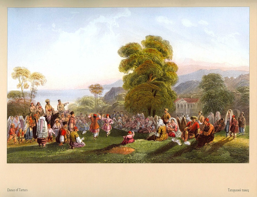
26.Tatar dance
“In Massandra, in a villa belonging to Prince Vorontsov.”
27.Grotto in Gurzuf
“Mount Ayu-Dag is visible in the background.”
28.Mount Chatyr-Dag
“The altitude is about 5,200 feet. View from the path leading to the top of Mount Demedzhi.”
The drawing is a magnificent example of a panoramic landscape. In the foreground are the spurs of Mount Demerdzhi. In the center is one of the most remarkable peaks of Crimea - Chatyr-Dag (translated from Turkic as tent-mountain). The mountain ranges are separated by the Angarsk Pass, hidden by thick fog, through which in 1824-1826. paved the first road from Simferopol to Alushta. The artist somewhat exaggerates the height of Chatyr-Dag (5200 feet = 1585 m); in fact it is 1525 m.
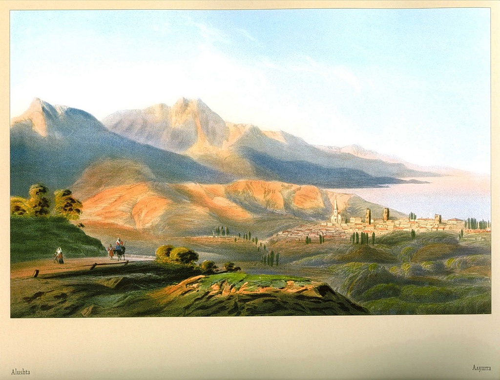
29.Alushta
“Formerly a large city, ancient Hellene. The destroyed towers are the remains of fortifications erected by Emperor Justinian in the 5th century. View from the upper road leading to Simferopol.”
Calling Alushta the city of the ancient Hellenes, the artist, of course, was mistaken. The information about the fortifications is correct, but with amendments. They were erected not in the 5th, but in the 6th century. (a more precise date is 560). The Byzantine historian Procopius of Caesarea narrates that under Emperor Justinian I (reigned from 527 to 565), the fortresses of Aluston and Gorzuvites (modern Gurzuf) were built on the South Bank. This is the first written mention of Alushta. The architectural dominant of the city, shown in the picture, is the Orthodox Church of St. Theodore Stratilates (consecrated in November 1842). It was erected on the initiative and personal instructions of M.V. Vorontsov (architect G.I. Torricelli). The church was built according to the type of rural churches in England, using Gothic elements, which corresponded
about romantic trends in architecture of the 20-40s. XIX century The building, partially rebuilt and modified, has survived to this day.
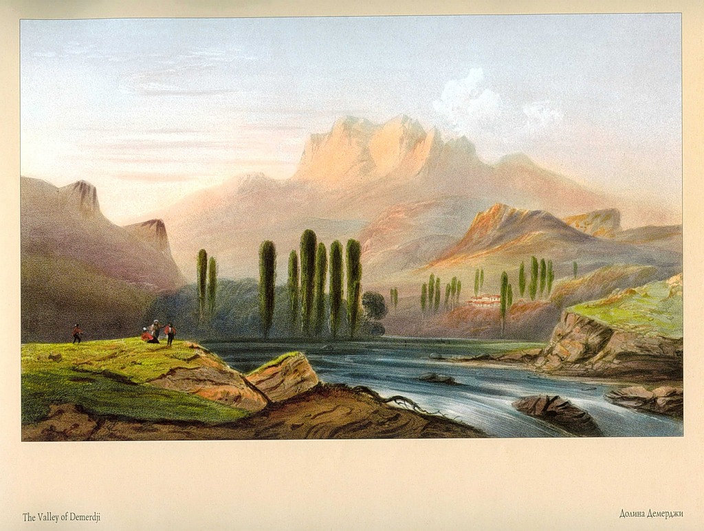
30. Demerdzhi Valley
Demerdzhi (translated from Turkic as Kuznetsgora) is part of the mountain system that covers the Alushta Valley from the northeast. The Demerdzhi-Uzen River originates on its slopes.
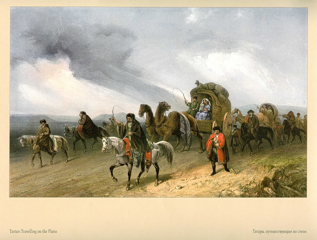
31.Tatars traveling across the steppe
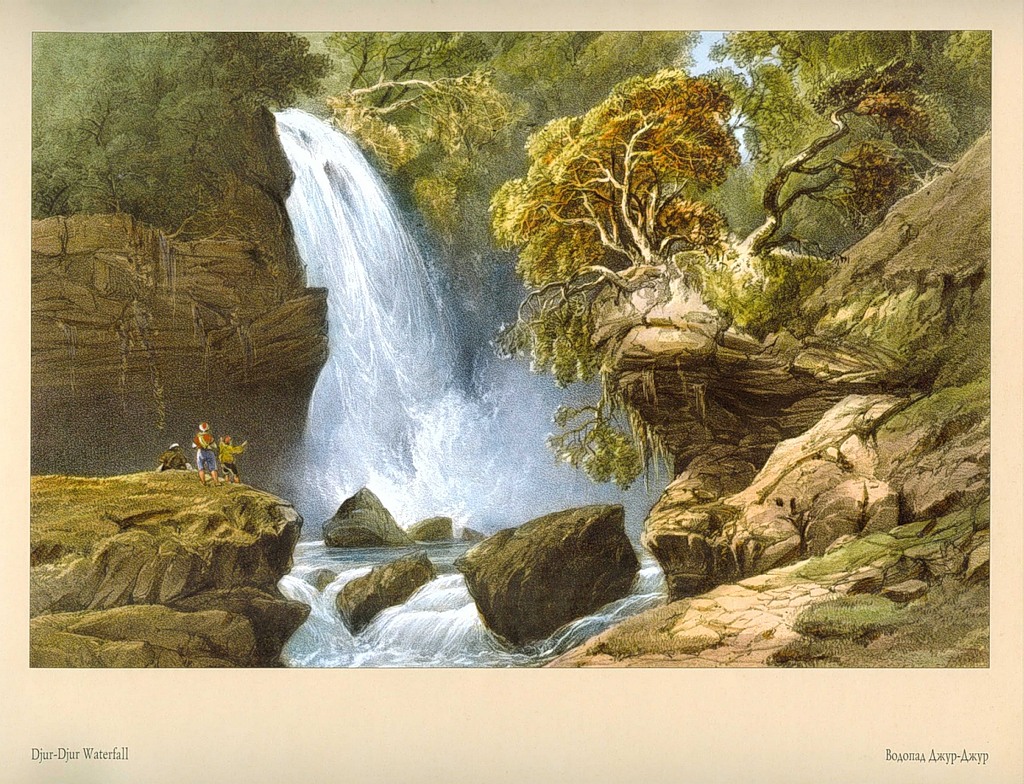
32.Jur-Jur waterfall
“Near the village of Buyuk Uzen; this is the largest cascade in Crimea"
The village of Biyuk-Uzen is now the village of Generalskoye, near Alushta.
33.Salgir River
“View near the village of Mahmud Sultan.”
The correct name of the settlement is Mamut-Sultan (now the village of Dobroe), on the road from Simferopol to Alushta.
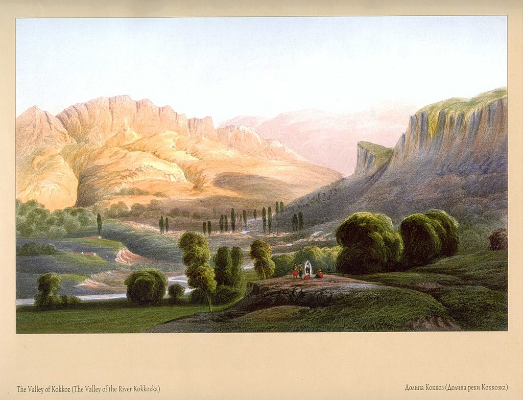
34.Kokoz Valley
“Also called Belbek; one of the most beautiful in Crimea.”
The Kokkozka River is a left tributary of the river. Belbek. Its picturesque valley cuts deeply into the slopes of the main ridge of the Crimean Mountains. The village is located in the gorge. Kokkozy (modern village Sokolinoe, Bakhchisaray district).
35.Simferopol
“View from the observation tower in the city center, looking towards the mountains, the highest of which is Chatyr-Dag. This city, the current capital of Crimea, is located on the Salgir River, which separates the new and old city. Its motley population, including Tatars, Greeks, Armenians, Jews, Germans and Russians, numbered about 15 thousand before the war.”
The division of Simferopol into “old” and “new” parts was certainly noted by all travelers. The old city is the Tatar settlement Ak-Mechet (White Mosque), known since the beginning of the 16th century. Here was the residence of the Kalgi Sultan, the viceroy of the Crimean Khan. Ak-Mosque has a distinct oriental flavor. The new city - Simferopol (translated from Greek - city of benefit, city-gatherer) was founded on the left bank of the river. Salgir in 1784. It is distinguished by a clear layout and European character.
36. Uzembash Valley
“View from the path leading to Alupka across the Yayla ridge”
This means R. Biyuk-Uzenbash (the artist mistakenly calls it Uzembash), which originates on the slopes of the Yalta Yayla.
37. Remains of Genoese fortifications on Chufut-Kale
There is an obvious mistake in the title. The Genoese's possessions were concentrated on the coast; They did not control the interior regions of the peninsula. Chufut-Kale is one of the most famous “cave cities” of Crimea. Located about three kilometers from Bakhchisarai, on a high steep plateau. Already in the 10th century. The first defensive structures were erected here to protect the local population from the attacks of nomads. The ancient name of the settlement is unknown. At the end of the 13th century. was captured by the troops of Nogai, one of the commanders of the Golden Horde, and received the name Kyrk-Or (Forty Fortresses). After the formation of the Crimean Khanate (30s of the 15th century), until the capital was moved to Bakhchisarai, the city served as the fortified residence of the khan. From the middle of the 17th century. the Tatars leave Kyrk-Or; only the Karaites remain to live there. They were considered Jews, so the city was named Chufut-Kale (Jewish Fortress). The Karaites are a Turkic-speaking people (possibly descendants of the Khazars); professed a religion close to Judaism. C. Bossoli witnessed the last period of the history of the city, which was still inhabited. By the middle of the 19th century. it was depopulated, the inhabitants moved to Evpatoria, Bakhchisarai, Simferopol, where they were engaged in trade and crafts. The drawing depicts an ancient road, fortress walls and the South Gate of the city. In the distance, on a cliff, there are 2 residential buildings XVIII - early. XIX century In one of them lived the famous Karaite scholar and expert on ancient manuscripts Abraham Firkovich, whom his contemporaries called “the guardian and patriarch of Chufut,” with his family. These were the last inhabitants of the once prosperous, but now abandoned and deserted Chufut-Kale.
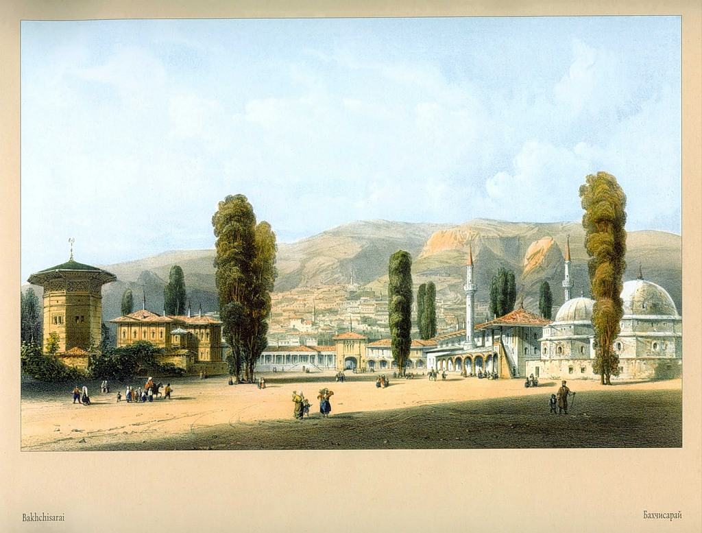
38.Bakhchi-Saray
“Ancient Tatar capital of Crimea. View from the large courtyard of the Khan's palace. On the right are the graves of the khans and a large mosque; on the left is the Khan's palace; in the center is the entrance gate; in the distance is part of the city rising like an amphitheater along the slopes. The population, mostly Tatars, exceeds 12 thousand.”
Bakhchisaray (literally - palace in the gardens) has been the capital of the Crimean Khanate since the end of the 15th century. The last Crimean khan, Shagin-Girey, abdicated the throne in 1783, and Crimea came “under the Russian State.” The palace was erected at the beginning of the 16th century, and subsequently, until the end of the 18th century, it was rebuilt several times. The drawing does not include an important architectural part of the palace ensemble - the tomb of the beloved wife of Khan Crimea-Girey Dilyara-Bikech (according to legend, this is what Maria Pototskaya was called in the harem). Judging by the perspective, the artist was located in the depths of the courtyard, right on the elevation of this monument. The tall tower on the left is called Sokolina. Tradition says that from here the khan's wives watched falconry and the military lists of the sovereign's guard. During the Crimean War, the palace complex served as a rear hospital for the Russian army. Nikolai Ivanovich Pirogov worked here.
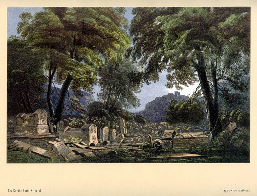
39. Cemetery of Karaite Jews
“Called the Valley of Jehoshaphat, near Chufud Kale.”
For the Karaites, the Josaphat Valley near Chufut-Kale is a traditional and holy burial place. Researchers have different opinions about the time when the necropolis appeared. Some believe that the oldest burial is about
dates back to the middle of the 13th century. Burials took place here in the 19th century. The vast cemetery was a mass of limestone and marble tombstones visible from the nearby slopes. Among them grew centuries-old oak trees, cutting which was considered a great sin. As nineteenth-century travelers noted, “the venerable Rabbi Firkovich read and copied the inscriptions from all the countless tombs of the Valley of Jehoshaphat.” The valley is named in memory of the valley of the same name near Jerusalem.
40. Remains of a large Genoese fortress in Sudak
There are many inaccuracies in the spatial depiction of the Sudak fortress, but the artist’s impressions are brilliantly expressed: this is History itself, harsh and inexorable. The complex and contradictory history of Sudak (founded in 212) is evidenced by the toponyms: Sugdak, Sudak - among the eastern peoples, Sugdeya - among the Greeks, Surozh - among the Russians, Soldaya - among the Italians. The fortress is traditionally called Genoese, because the last significant period of its history is associated with the rule of the Genoese. But the architectural appearance of the fortress allows us to trace the history of the intense political struggle between Genoa and Venice, immortalized in stone.
Both republics sought to control the centers of world trade, including Sugdea, through which the Great Silk Road ran. According to reliable sources, since 1206 Soldaya has been the largest Venetian trading post in Crimea. The constant threat of attacks by the Mongol-Tatars (the first invasion in 1223), then by Nogai’s troops prompted the Venetians to reconstruct old and build new fortifications, in particular the famous Consular Castle, which has survived to this day (in the picture - on the far left). The Venetian consul stayed here since 1287. Meanwhile, the positions of the Genoese in Crimea were strengthened. They founded a significant trading post in Kafa (Feodosia), subjugated Balaklava (Chembalo), Kerch (Chekio). Soldaya's fate was sealed. In 1365, the Genoese launched a surprise attack and took the city by storm. Having taken possession of the fortress, they improved and significantly supplemented the defense system created by the Venetians. The main population of Soldaya are Christians (Greeks, Armenians), but there were also many Muslims (Tatars, Arabs). The picture shows one of the mosques (the building has been preserved).
41.General view of Kara-su-Bazar
“This city, with about 16 thousand inhabitants, is located on the Karasu River. View from the minaret. In the foreground is part of the city and the road leading to Feodosia; on the other side of the river, on the right, there is a caravanserai, formerly a fort; in the center is the Russian church, to the left is the Greek one. In the distance are the Karabi-Yayly mountains.”
Karasubazar (Market near the Black River) is an important trade center connecting caravan routes from the north to the ports of Kafe (Feodosia) and Gezlevu (Evpatoria). The first written mentions date back to the end of the 13th century. The caravanserai that the artist points to is Tash Khan (Stone Palace), where merchants stayed and goods were stored. Traces of this monument are visible to this day. Since 1945, Karasubazar was renamed into the city of Belogorsk.
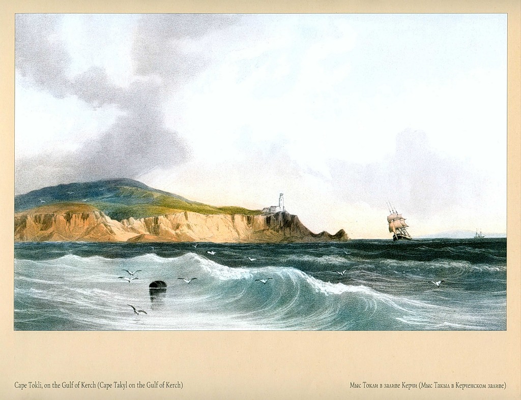
42.Cape Tokli (Takyl) in the Kerch Bay
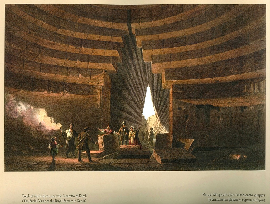
43.Tomb of Mithridates, near the Kerch infirmary (Tomb of the Royal Mound in Kerch)
“A lot of jewelry was found in this grave and was sent to St. Petersburg.”
The title of the drawing and the author's annotation contain obvious discrepancies with historical facts. The drawing depicts the tomb of the Royal Mound. According to archaeological data, the Royal Mound was erected in the 4th century. BC e. and was intended for the burial of one of the most powerful rulers of the heyday of the Bosporus - King Leukon I (389-349 BC). Mithridates lived later, in the 2nd century. BC e., reigned 109-63. BC e. As a result of the conspiracy, the Bosporan king lost power and, not wanting a shameful death at the hands of his enemies, took poison. However, the poison did not work, because the king took small portions of poisons all his life, fearing poisoning. Then the king turned to his faithful bodyguard with a request to use weapons. It is not known for certain where the famous Mithridates is buried.
44.Kerch from the side of the upper road to Yenikale
“Behind the city is Mount Mithridates; the building on the hill, similar to a Greek temple, is a museum. This is a completely modern city with 12 thousand inhabitants of all nationalities.”
Kerch (Pantikapaeus) is one of the oldest cities in Europe. Founded in ancient times (VI century BC) by immigrants from Greek city-states, mostly from Miletus. Around 480 BC e. Panticapaeum, the largest among the new Greek cities, located on both sides of the Kerch Strait, unites them under its rule and becomes the capital of the Bosporus Kingdom. The time of the highest economic and cultural prosperity of the Bosporus is the 4th century. BC e. This is a large trading center, the main supplier of grain for Athens, island Greece, and the cities of Asia Minor. Luxury items, fabrics, weapons, and expensive ceramics were imported into the Bosporan lands.
On the left you can see the dome of the Church of John the Baptist (late 9th - early 10th centuries) - a monument of early Byzantine religious architecture. This is the oldest Orthodox church in Eastern Europe, still operating today.
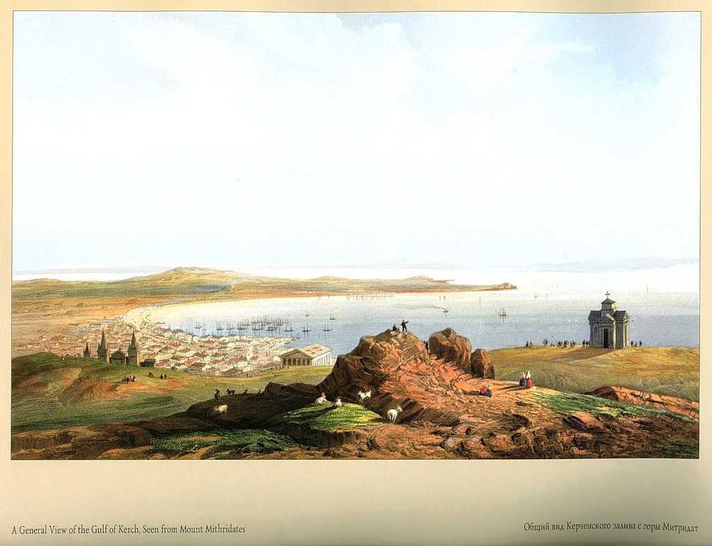
45.General view of the Kerch Bay from Mount Mithridates
“Rock with carved steps,
placed in the foreground is called the throne of Mithridates. As they say, the great king of Pontus came to this place to proudly survey the large fleet assembled in the harbor, which so terrorized the Romans. The monument on the right is modern and was erected in honor of the Russian governor. To the left, below, the city stretches; in the distance there is a cape and the Yenikale Strait leading to the Sea of Azov.”
46.Fort Arabat
From the Kerch Peninsula, a narrow sandy spit of Arabat Strelka stretches to the northwest, separating the Sea of Azov and its Sivash Bay. At the very beginning of the spit was the Turkish fortress of Arabat, built at the beginning of the 18th century. according to projects of French military engineers.
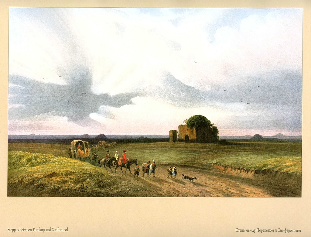
47. Steppe between Perekop and Simferopol
“Ruins of a mosque near Arta. Mounds of earth called mounds can be seen in the distance. It is assumed that they were used as road and distance markers. Burials were discovered in them in Kerch.”
Arta is probably the village of Orta Ablam. Existed until 1926
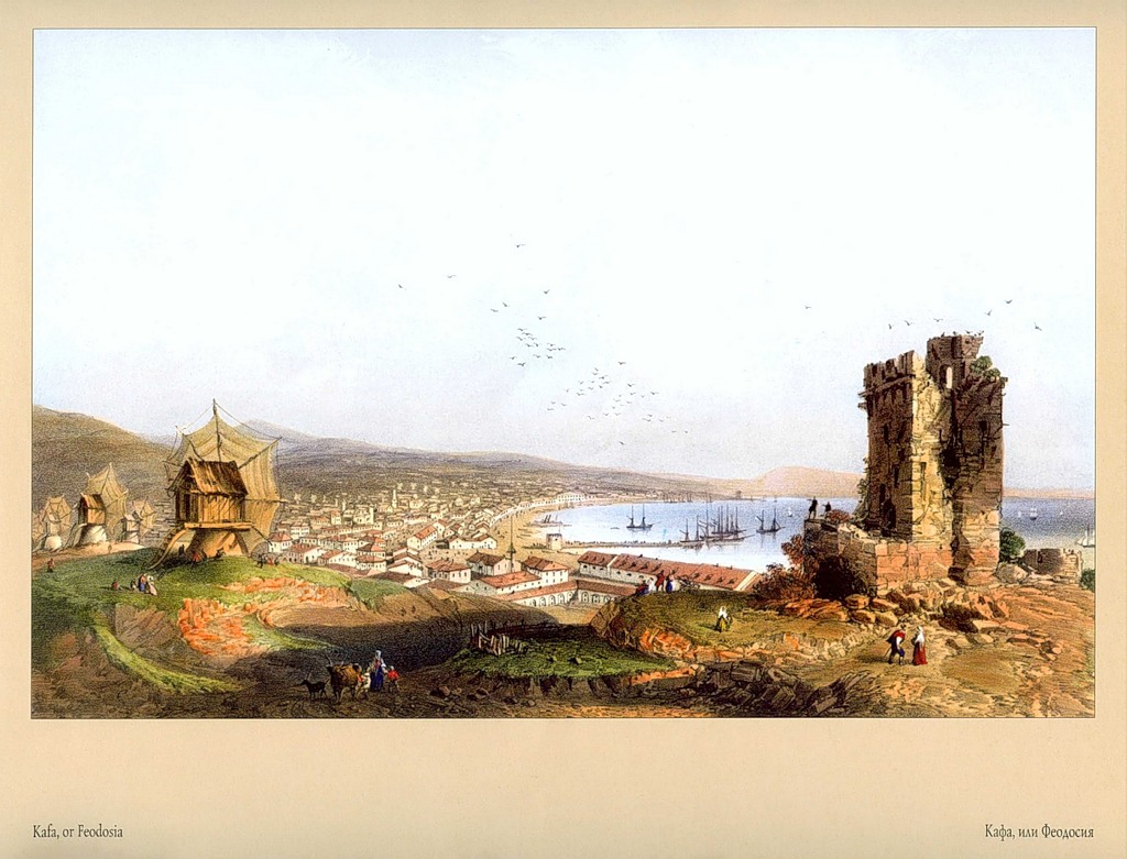
48.Kafa, or Feodosia
“View from the ruins of a Genoese fortress. It was the largest possession of the republic on the peninsula. The city, formerly the most densely populated, now has no more than 10 thousand inhabitants.”
Theodosius (translated from Greek - given by God) was founded in the 6th century. BC e. merchant seafarers from ancient Greek Miletus. During the period of the highest prosperity of the Bosporan kingdom (IV century BC), the Feodosian trading post was part of it. However, it remained a major trading point through which the Bosporus exported grain and other goods to the capital. The ancient center of economy and culture fell as a result of the invasion of barbarians (Huns) in the 4th century. n. e.
49.Bosphorus “View from the European shore, at the entrance to the Black Sea.”
The work is called "Bosphorus", probably in consonance with the name of the famous strait. In fact, this refers to the Cimmerian Bosporus, as the Kerch Strait has been called since time immemorial. According to the annotation, it would be natural to assume that the artist meant the Kerch Peninsula by the “European coast”. Consequently, we see the “Asian coast”, i.e. Taman. But the relief and buildings indicate that the picture depicts the Kerch fortress on Cape Ak-Burun, visible, presumably, from Cape Zmeiny. Thus, both the observation point and the depicted object are located on the Kerch Peninsula, on both sides of the Kerch Bay.
50.Perekop
“In the foreground is a ditch made by the Tatars across the isthmus; in the background you can see the city. The main occupation of the population of one thousand is trading in salt.”
Crimea is connected to the mainland by the narrow (8 km) Perekop Isthmus. This only land road to the peninsula has always been of great strategic importance. Along the entire isthmus, from the Karkinit Bay of the Black Sea to the Sivash Bay of the Azov Sea, stretches the famous Perekop ditch and rampart. Who and when built the grandiose fortification is not known for certain. It is generally accepted that it is associated with the period of penetration of Scythian and Sarmatian tribes into the Northern Black Sea region, and can be dated quite widely - 7th-3rd centuries. BC e. Many ancient authors mention this place. In particular, the Roman scientist Pliny the Elder (1st century AD) wrote that the ditch served as a canal between the seas, and at the narrowest point of the isthmus was the city of Taphros (translated from Greek as ditch). C. Bossoli did not have such information, but it was not by chance that he attributed the building to the era of Tatar-Turkish rule. At this time, there was a powerful outpost with the main fortress Op-Kapu (literally - gate fortress). The city mentioned by the artist is Perekop; five miles away from it was the town of the Armenian Bazaar. They served as a kind of transshipment trading points. The so-called Chumatsky Way, along which salt was exported from Crimea to the mainland.
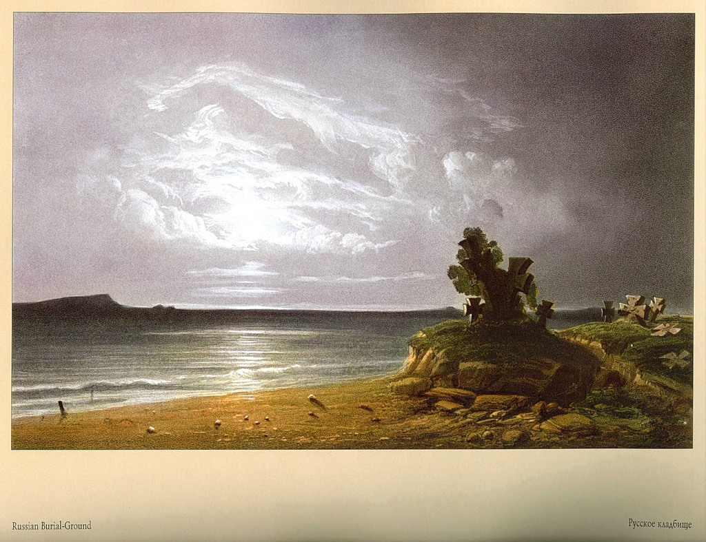
51.Russian cemetery
“On the shore of the Rotten Sea, near Perekop.”
Rotten sea _ Sivash. This is a vast shallow and very salty bay of the Azov Sea. When westerly winds drive water from Sivash into the sea, the coastline of the bay is exposed for 5~6 km. Benthic algae decompose, emitting a pungent odor of hydrogen sulfide.
52. Snake Island
“In the Black Sea, near the mouth of the river. Danube".


Download
Archive size 13.02 Mb, downloaded 364 times